 Live Music Archive
 Librivox Free Audio
 Metropolitan Museum
 Cleveland Museum of Art
 Internet Arcade
 Console Living Room
 Books to Borrow
 Open Library
 TV News
 Understanding 9/11
tv The FOX Report With Shepard Smith FOX News October 29, 2012 7:00pm-8:00pm EDT
7:00 pm

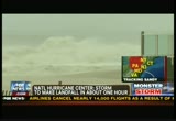
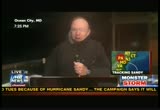
normal duty. two sentinels from the third infantry regiment from guarded every day since 1948 even with hurricane sandy blowing in. thank for inviting us into your home tonight. that's it for this "special report." that is really fair, balanced and unafraid. >> shepard: this is "the fox report." tonight it's coming ashore and a crane teetering pair alsoly on a manhattan as hurricane sandy does its job. and take a look at this. the crane appears to be just hanging on. the new york city mayor says it's not in danger of falling. we'll take you live to the scene. as the monster storm moves on to it land and nails the northeast. >> hurricane on steroids, i think she just juiced up. >> do not underestimate saving
7:01 pm

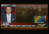
lives. >> this looks like another time where we need to come together all across the country. >> shepard: tonight, the epic threat from super storm sandy. ' its first from fox this monday night, seems the forecasters were right on almost every single point. the east coast of the u.s. now taking a direct hit from the most powerful storm ever to hit the region.
7:02 pm
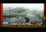
ever in recorded history. and tonight, officials in maryland are reporting the first death they have just reported it. and what they are calling a storm related crash. a life look now point pleasant in new jersey where the sun has set near the spot hurricane is now coming ashore: they say the monster storm will spread devastation far and wide on east coast and far beyond. one of two main roads into atlantic city, new jersey. look at this. it's washed out. hours before sandy even came ashore. the city shut down its casinos for but the fourth time in its history. today, governors up and down the east coast warned people to get out of the danger zones or stay inside. >> this the most catastrophic event that we have faced and been able to plan for in any of our lifetimes. >> this is going to be a long haul. the days ahead are going to be very difficult. there will be people who die and are killed in this storm. >> this is not a time to be a
7:03 pm

show off. this is not a time to be stupid. this is a time to try to save yourself and your family. >> shepard: new jersey governor christie who tonight is angry. even before landfall sandy's winds were already doing damage. this a construction crane that partially collapsed in midtown manhattan just north of times square. a closer look here fire department officials tell fox news they closed off the surrounding streets, ordered people on the top floors of nearby buildings to evacuate. and officials say so far no injuries. that crane up 65 stories. look at this. the super storm is shut down mass transit in boston, philadelphia, washington, d.c. and new york. this is grand central terminal. and here the time square subway station. never have i seen it like this. officials say they cannot tell us when the trains and buses will be running again. but certainly not for tomorrow morning's rush.
7:05 pm
>> shepard: details of why less than a minute. first from steve, what's the latest from officials there? >> officials are really trying to emphasize that people should not go out. that they should stay in their homes. and perhaps the strong sexual offense testimony to this has been from maryland's governor. here is what he had to say earlier. >> there will, undoubtedly be some deaths that are caused by the intensity of this storm. by the floods, by the titled surge and by the waves.
7:06 pm

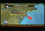
the more responsibly citizens act the fewer people will die. >> you can see it gets so strong you have to brace yourself. we still have electric power but 40,000 people in maryland have lost their power, mainly in the baltimore area and thousands more expected to over the next 24 hours, shepard. >> shepard: steve harrigan live along the shore in ocean city, maryland. fluke we have just gotten word from the national hurricane center two different important pieces of information. one, this storm is to make landfall in about an hour and number two, it's no longer a hurricane. and may, in fact, be something even worse. let's go to the wall and i will show you what i am talking about. we have talked all day how the belief was this hurricane would turn into something else. a hurricane has tropical signatures that stay with it as long as it moves along like a hurricane. this one has now added another storm to it. this winter storm that's been coming from the west. they have combined, the center of the storm is no longer a
7:07 pm
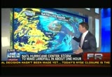
tropical like an eye, to what you see coming ashore here right along the jersey shore right about here is now what they are calling a super storm. it's a combination of a hurricane, a winter storm that's come from this way and arctic air that's come from the north. pushing into land much faster than anybody had anticipated it was moving at 15 miles per hour, 12 hours ago. it's now moving at 28 to 30 miles per hour. so that increases the forward winds above it. and it also decreases the amount of time that those -- that very heavy, on shore flow and the surge will effect the landfall. here are the biggest problems. let's go to the next map. the biggest problems have to do with this sturgeon. the sturgeon three hours ago he we were told the storm had speeded up, as a result, it would have been coming in about 5:00 or 6:00 eastern time. turns out that didn't happen. it's expected around 8:15. and 8:15 is high tide. that is absolutely a worse case scenario. let's get to janice dean in
7:08 pm

the fox weather center. janice, the hope was that 8:15, 8:30 high tides would not coincide with landfall. now it looks like that's exactly what's gonna happen. >> you are exactly right with the description that ear now talking about a subtropical storm. it has transitioned from a tropical storm to an extra tropical storm. so, instead of a warm core it has a cold core it interacted with that artic front and infused some cold air really sort of acting as gasoline on a fire. so this storm is strengthening and, yes, unfortunately, it looks like the worse of it could come at high tide along those very vulnerable sturgeon prone regions. i just want to show you, we were thinking that this had made landfall, and now the national hurricane center, national weather service is saying we're still waiting for landfall because it has made that transition. so, the center is not as evident as it typically would be. with a tropical storm -- landfalling tropical storm system.
7:09 pm

there is ocean city, again, can you kind of see that centered. that's why we thought the center had come on shore. because it made that transition within the last couple of hours, as a nontropical system that's why we are still waiting for the latest advisory telling us the exact landfall location and, shep, i just want to give you a location of some of the latest wind gusts that we are seeing. the latest at kings port, new york, west end of high tide in two hours. back to you. >> shepard: janice dean, thanks very much. live in the weather center. back to her with breaking news. this is from point pleasant, new jersey, which all day long has been taking a pounding and now the storm is so severe there that even our satellite truck can't get out. rick leventhal is live on scene where he has been all day. rick, it sounds like bigger than most they have expected. >> things have taken a dramatic turn for the worst. in just the past few minutes. water rushed on to ocean avenue, on to washington avenue. the intersection where our hotel is located. the water has now breached the parking lot. what was once just a puddle on
7:10 pm
ocean avenue is now at least two feet of water. and it's rushing in from the ocean in waves. coming down washington avenue. trees are bent. there is a large shed that broke free the size of a one car garage now sitting in the middle of the intersection. the water is continuing to rise around us. pretty eerie feeling. our truck had to put the dish down and pull the ceabilities. we are concerned about our other vehicles. we are on high ground right now but looking out from a second third story balcony at the water rising in the street below is pretty unsettling. bill. >> shepard: rick leventhal live. this sturgeon is what we are concerned about. here is sort of the center of it, right? the worst of it for every storm is always to the right. the northeast quadrant is always the worst. so that's what's coming into new york city. rick described what the weather first alert forecasters locally have been fathering all day long and that is that at some point in a matter of minutes, not hours, water will rise from here to here.
7:11 pm

that's a sturgeon. it happens very quickly and the fear is that this afternoon, first map, please, it's going to happen in new york city. high tide around -- this is new york city lower manhattan, all these yellow areas are mandatory evacuation areas. all over this island. next map and you will see that it's really all over the five burrows of new york city. brooklyn, staten island, the lower end of manhattan, queens and all along these beaches. all mandatory evacuations. a sturgeon is on the way. next map. it's going to come right up through the center of all of this. it's gonna batter into new york city. this is fire irelandal island "island. a storm that cut a government cut a long time ago. dude road in the hamptons, all of this expected to get a sturgeon somewhere between 6 feet and 11 feet. the local emergency managers are telling us it may on 00 high side of that. because we have a combination that never in the history of this region has been seen. and that is a storm coming
7:12 pm
ashore directly at high tide during a full moon. and truthfully, a 6 to 11-foot sturgeon and all of this is in big trouble as is the subway system in lower manhattan. news is breaking now in new york city as not only we have that crane disaster but also word of a four story apartment building which caught fire and has now collapsed. we're told it's at 14th street and 8th avenue which would be west village meets the chelsey area. authorities are on scene. we are working to get our cameras there. that crane is still dangling just above times square. now officials say inspectors have to climb up there to take a look at it somehow. we will get a live update there our journalists are positioned up and down the eastern seaboard for the storm of 2012 like nothing the northeast has ever experienced and it will come ashore tonight as fox reports live. [ male announcer ] alka-seltzer plus presents the cold truth. i have a cold, and i took nyquil,
7:13 pm

but i'm still stubbed up. [ male announcer ] truth is, nyquil doesn't unstuff your nose. what? [ male announcer ] it doesn't have a decongestant. no way. [ male announcer ] sorry. alka-seltzer plus fights your worst cold symptoms plus has a fast-acting decongestant to relieve your stuffy nose. thanks. [ male announcer ] you're welcome. that's the cold truth! [ male announcer ] alka-seltzer plus. ♪ oh what a relief it is! [ male announcer ] try new alka-seltzer plus severe allergy to treat allergy symptoms plus sinus congestion and pain. or that printing in color had to cost a fortune. nobody said an all-in-one had to be bulky. or that you had to print from your desk. at least, nobody said it to us. introducing the business smart inkjet all-in-one series from brother. easy to use, it's the ultimate combination of speed, small size, and low-cost printing.
7:14 pm

[ mom ] we already have a tv. would you like to know more abo it? yeah, but let me put my wife on speaker.
7:15 pm

hi! hi. it's led and it has great picture quality. i don't know... it's ultralim... maybe next year. you cod always put it on layaway and pay a little at a time. alright. we'll take it! ah! i love you! hmm! ahem. football. [ male announcer ] shop now. get the hottest brands on your list today... like the lg 55 inch led tv. and put it on layaway now so you have more time to pay. walmart.
7:16 pm

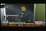
the facade of that four story building collapsed right arnold -- just about 45 minutes ago. a fire and then the collapse. fire department reportedly has more than 100 firefighters on scene. no word on what caused the collapse. we are expecting updates soon and we will will get them to you. as i mentions the storm is
7:17 pm
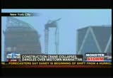
still coming ashore. and it's kazmierczaking all sorts of problems in this region. one that began this afternoon when we had a perilous crane collapse high in the sky. engineers and inspectors planning to climb to the 74 flights of stairs to get a look at this crane. you see on the left-hand side of your screen what it looked like before it collapsed. and then we will will wipe to it a picture that will show you what has happened now. officials say that's on the right-hand side of your screen. and there it is full screen. officials say the crane collapsed this afternoon at a construction site just north of times square. 7th avenue, i believe, and about 57th street. meteorologists say at the time that far above ground, the wind gusts have sandy may have topped 95 miles per hour. on "studio b" today, a witness told us she drove right under the thing. >> crane, it looked like it was about to fall right on me. >> it looks like it's hanging in the middle of the street. and they didn't close off the top.
7:18 pm

so pieces of debris are falling from the construction site. >> again, before and after look from our station wnyw what new yorkers watch fox 5 here in new york. on the right side circle crane. aftermath on the right. i have spoken with crane experts who tell us it is going to be very difficult to get that thing down. our julie banderas joins us live. can you see the crane from the balcony where you are. >> this is where i live. it's impossible to get this thing down. i have been watching this thing from last year and a half. during hurricane eye crean. the winds are 100 miles per hour. this is video i took from my balcony. the crane is weighing from the roof. up on the 70th floor of the boom of the crane is hanging from the 157 tower. tallest residential building. eventually reach 0 stories tall. housing the most expensive apartments in the city. in fact the penthouse sold for
7:19 pm

$90 million. you would think that this construction company would spend that money wisely and make sure that all the equipment is safe. the builder, bogus lend lease which is responsible for the site safety has just issued a statement i'm just going to read parts of it for you, shep. it's a long one to. make it short. the hurricane storm winds have pushed the crane boom over the cab section ever the high rise crane. new york city emergency personnel are on the site working to get people away from any potential impact area should any additional failure takes place. the crane was last inspected on october 26th and the builder is working with structural engineers and the department of buildings on evaluating any additional measures that can be taken to secure the boom and crane structure. current weather and wind conditions remain very severe. so far no injuries but, you know, we're waiting to watch and see what happens with this thing. >> shepard: julie banderas on the crane reporting live. julie thanks very much. now we are getting new information in about this building collapse in new york city. it's my understanding we'll have some live pictures for you. here it is or that was it. here are the pictures.
7:20 pm

you can seat facade has just collapsed. it's my wrund standing that this if a sat is on the avenue. so this is 8th avenue is one that runs northbound in the city. the entire front has come off. we will go there live and update you on the storm. i have brand new coordinates in atlantic city. that's next. with the seeds getting under my denture. super poligrip free -- it creates a seal of the dentures in my mouth. even well-fitting dentures let in food particles. super poligrip is zinc free. with just a few dabs, it's clinically proven to seal out more food particles so you're more comfortable and confident while you eat. super poligrip free made the kiwi an enjoyable experience. [ charlie ] try zinc free super poligrip.


7:23 pm
>> shepard: sandy is no longer a hurricane. it still has hurricane force winds, very serious hurricane force winds but no longer has tropical cyclone characteristics, meaning it's a cold water storm now not a hot water that storm came in from north, mixed in it and made it the super storm. we now know that the storm is 20 miles south of atlantic city, new jersey. that's right this minute. and it's moving to the west and the north. so the bad news for anyone who cares at all about atlantic city is, it's going to come in
7:24 pm

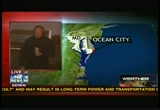
just south of click city if the national weather service is right. that's significant because, remember, everything on this side of where it comes ashore gets it a lot worse than anything on this side. so atlantic city, of course, will take a beating there are real concerns about new york city as it continues to move on, a sturgeon expected right at high tide just about one hour from now. our steve harrigan is right in the middle of it all in ocean city, maryland, where, steve, i'm guessing over the last, what, hour or so, your wind directions have changed considerably? >> >> that's right, shepard. the winds really shooting through ocean city streets right now. and they are strong enough to snap signs. they have been very adamant about trying to keep people off the road. emergency rescue workers. the only vehicles we have seen out in the last hour or two are humvees with national guard. you have really got to be crazy out in a vehicle right now. and more and more as these conditions do continue to get worse. we're hearing about more roads closed either because they are
7:25 pm
covered with sand or water or simply too dangerous because of the wind. especially we're hearing more bridges shut down, especially for certain types of vehicles. shut down because moving around here is getting too tough. if you look out to the water, we are seeing some really amazing scenes of 15 to 20-foot waives coming through the night and crashing white. we have seen the sea wall over top several times and really the proprietor of this hotel was pretty smart not to rent out the lowest floor because there is about 3 or 4 inches in it right now. we have seen people taking up microwaves and taking up bedding to try to salvage it i think the real concern is what we haven't seen yet. because we haven't been able to move. on the bay side of this area. that's where the water has been unable to escape. that's come first light we will see serious flooding, shepard. >> shepard: steve, have you been through a lot of these things as far as winds and waves go. does this feel like a category 1 storm to you? what's he it like being in a freezing storm? i have never experienced that.
7:26 pm

>> it's very bracing to be in a freezing storm. i have never experienced it either and i realize i haven't brought the right supplies for it at all. but as far as the conditions go, it certainly feels like a category 1 hurricane gusts of wind. when you see small objects fly around and when you see a stop sign snap in half, that's a prettyood indicator, even without holding an mom ter in the air that you are in a hurricane. >> shepard: explaining to new yorkers what's about to happen. let's go over to nic gregory if we could. >> even though the center has come on shore the flood. the fox 5 guardian close in view is showing light showers. the wind is pounding the coast at gusts of over 60, 70 miles per hour in a lot of places. now, notice again a little wind shift out of the southeast. everybody east to northeast. 35 to 40 miles per hour. those are the sustained winds. here to are the latest gusts.
7:27 pm
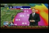
gusting' 2 at kennedy. 72 at farming dale. 474 in towards newark and caldwell and gusting to 61 along the south shore of connecticut by bridgeport. the highest gusts have been in that general range. highest gusts we have seen so far around icelet at 90 miles per hour and eton's neck as well. rough sea also continue to pound the coast. the surface continue to rise. i will look at some new totals of surge now going on. i'm sure we are going to have a huge number coming in from sandy hook. i'm going to go look at the level of the water. >> shepard: talking about surge levels at sandy hook, sandy hook new jersey which is one of the weather control stations in the state of new jersey. we're expecting bad numbers here. this is long island and long island sound. now, back up just a little bit if you would. keep in mind, this storm is moving like it's down here and moving like this. so all of these winds are coming like this. the storm -- this is fire island and do you dune load roa.
7:28 pm

spit of land with houses in the middle and the bay on one side and the ocean on the other. great fears for this mass of land. here is the other big concern. these -- the winds are sending the water into long island sound. you can see how wide it is on this end. when you get down here closer to new york city to burrow queens, how skinny it is and dumps down into here. the concern is over a four hour period they are estimating the new york city mayor came forward today along with meteorologists to tell us ha that this water is going to come into long island sound and as it continues to move from here to here will take about four hours. close to 100 miles. from here to here will take four hours. and when it it gets here, because of this pounding relentless wind, they are very concerned that it could flood much of this region. the worst of this storm is not yet over. and as we continue to track it this storm, the largest ever seen in this part of the country, we will continue to bring you coverage, including this video from space that shows just how big this storm is. about a thousand miles wide
7:29 pm
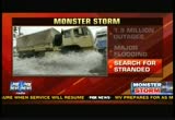
with up to 60 million americans potentially in its path. nearly one fifth of the nation's population. as of right now, officials from north carolina to vermont report close to 2 million people without power. a number that's likely to rise considerably as the high winds continue. but there are reports of major flooding as the sturgeon rushes ashore. places like atlantic city, new jersey, it's already happened. on long island, new york. it's beginning to happen. and in the battery of lower manhattan, it's happening as well. in delaware, the national guard has been patrolling flood zones looking for stranded victims. military officials is a say they have moved planes from dover air force base in anticipation of the storm. our doug mckelway is live. what are conditions live like there now? >> not all that bad. just about an hour are a or two ago. governor had a press conference in the hotel we are staying. it would be premature that the beach dodged a bullet here but it looks like we are headed in that direction.
7:30 pm
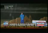
something like 660 people from delaware are in cheryl's tonight but there have been no major injuries and no deaths. the other piece of really good news, just as steve harrigan described about 40 miles to the south of ocean city, right here we are on the back end of the storm now. so the wind is coming from the west. yesterday it was coming from the northeast. we're expecting high tide at 8:10 just about 40 minutes away. that water should be lapping up right against these dunes as it was last night. it's not. it's still pretty far out. that's because of this westerly wind which is going to keep the sturgeon from overtaking the dunes here tonight. it's going to be pushing it back out to sea, that's very very good news and we'll keep our fingers crossed that it continues to happen at 8:10 when high tide occurs, shep? >> shepard: once the eye went north of you, it turned the winds around so pushing the surf back out. i'm wondering how much that beach it took with it. beach erosion is a huge concern. >> it is a huge concern. the guy who administers beach erosion programs up and down the state of delaware was at
7:31 pm

that press conference today too. he said from his empirical evidence, that basically means from what he has seen today that things are very very good. he described it as sand and sand dunes are expendable. the infrastructure behind them is not. the fan is meant to wash away. the fan dunes are doing their job. we will keep our fingers crossed tonight, shep. >> shepard: mckel way, best of you and yours. brooklyn, queens, manhattan, staten island and the bronx. yellow areas again the zone a as they call it here those who have to evacuate. mandatory evacuation here. as the water, remember, there is a counterclockwise flow so the water pushes in this direction right between staten island and brooklyn and right to the tip of manhattan or the question is what happens here in the battery? this is the area where they have great concern for the subway system. once the wall is topped and local authorities say they believe the wall will be topped shortly at high tide, how much of it gets into the subway system. it's not fresh water, it's salt water.
7:32 pm
salt water corrodes and that is a worse case scenario for the largest subway system in america. we should know soon enough. we are approaching the bottom of the hour and the top of the news and our coverage continues with an update from the national hurricane center momentarily. we still run into problems. namely, other humans. which is why, at liberty mutual insurance, auto policies come with new car replacement and accident forgiveness if you qualify. see what else mes standard at libertymutual.com. liberty mutual insurance. responsibility. what's your policy?


7:35 pm

>> shepard: there is breaking news now on fox news channel. new video just in on the collapse of a building in new york city. this is 14th street. actually 8th avenue at 14th street in the chelsey section of new york city where the
7:36 pm
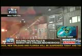
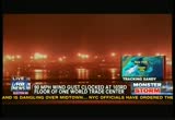
entire facade of a building has crashed into the street. we don't have any word yet on injuries but we do know that the new york city fire department or fire department of new york has some 100 pepper nell on scene and a number of engines as well. that entire area is shut down to vehicular traffic and otherwise. i'm told that the facade fell into the street. no report of any damage. again, a four story occupied apartment building in chelsey in new york city. part of the reason for this, we have just gotten word from the mayor's office that here in lower manhattan at the world trade center site they have just recorded a 90 mile-per-hour gust at the top of the world trade center. in addition from the mayor's office. we have gotten word of this. you can see here on the map the fdr drive runs all along the east side of manhattan from 20thth street all the way down to the tip of manhattan. the entire fdr drive, according to the mayor's office, is completely under water. that's the sort of thing that will change with the rising and lowering of the tide. but right now we know the
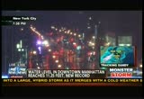
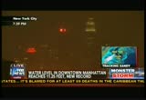
7:37 pm

surge is coming in as down in new jersey the storm is about to take is about to make landfall. here at the lower tip of manhattan, battery. the highest water ever recorded was 11.2 feet. that was recorded in 1821; 1821. it's now higher than that. and the flooding of lower manhattan has begun. david lee miller is right there in the battery in lower manhattan. no way to get a live signal out with the heavy wind so david lee is on the phone. what are you seeing? >> i'm seeing water and it rising very rapidly. the situation, shepard, very treacherous. we cannot transmit now because we have to move our satellite truck. the water is rising that quickly. it completely covers now a promenade, a walkway that only a few hours ago that was completely dry. and very ominous sign. off in the distance from where i'm standing now i can look across the hudson river on the other side of the river is jersey city. just moments ago, i just saw another one.
7:38 pm
huge, huge flashes of light. i am told by new york city police those are transformers exploding across the river in new jersey. this as you mentioned, as the wind intensity continues to increase. the water level only gets higher. nevertheless, despite the fact this is an area where there is a mandatory evacuation, there are still people here who say they are going to ride out the storm. some of their lights are still on but i'm told that's not for long. edson is saying the lights are going to have to come off. the power is going to be turned off as a precaution. once that happens, no elevators no, running water. as the water level continues to rise through the lower manhattan, people in these high rises might be on a high floor that is dry but they are going to be trapped. it is now time to evacuate if they have not already done so. that is why we are leaving this area to broadcast a short distance away as the water level inches towards battery park city and all of lower manhattan.
7:39 pm
>> shepard: it's happening, david lee at absolutely the worst time. there is a high tide that's going to hit in about 45 minutes there is a full moon as well. the record has already been broken where you are. david lee, does it look as if most supreme evacuated? >> most people have evacuated. we're there are roughly about 10,000 people that live in battery park city. i'm told about 15% of them have decided to stay on. you know what, shepard, from what i'm hearing they are now starting to reconsider and very quickly i should add because i heard you mention the world trade center a moment ago. i'm looking at one world trade center right now. there is a crane atop one world trade there are high gusts but the port authority of new york and new jersey that maintains the world trade center has issued a press release saying that contrary to some reports, the cranes are secure. there is staff on the scene 24 hours now to make sure the world trade center is safe but the world trade center not far from the rising waters of the hudson river. shepard? >> shepard: not far at all. david lee as you move to it higher ground.
7:40 pm
david lee, thank you. we are talking about this area all along the southern tip of manhattan. the weather authors had warned in this won't happen over a slow period, that there would be a slow rise all day all along manhattan and along the shores north and south of us. but that when the surge came, it would happen very quickly, the water would rise very quickly. just for a little perspective, there was a sturgeon that happened during hurricane katrina, not in new orleans but in south mississippi that was higher than 30 feet. the highest ever recorded. and that wiped out entire communities for a mile inland. here we are talking up to 11 feet and if it happens and the surge happens the way they have said, it will flood much of lower manhattan, it's already flooded the fdr drive along the side and it's just beginning because high tide is 45 minutes away. atlantic city's public safety director says much of that city is now under water. some pictures of road 30. one of the major roads into atlantic city. a writer for the philadelphia enquirer newspaper nearby sent us these pictures. part of the city's historic
7:41 pm
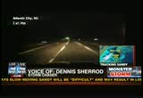
board walk is now in the sea. other parts have collapsed there. and the new jersey governor chris christie ordered all of atlantic city's casinos to shut down. he did that, it's only the fourth time officials have closed those casinos since the city legalized gambling more than three decades ago. storm chaser dennis sherrod joins us now. is he live in atlantic city. i'm hearing the water is still rising, dennis. >> that it is, shepard. i'm at bali's casino now. and i don't know -- i don't know if you see it but the water is quickly rising here. it's, in fact, the evacuation routes, everything are cut of off now. power is beginning to go off throughout the city. west of here, south of here. and i'm pretty much isolated in one little small spot now which i will probably be in the parking deck shortly. that will be my only dry spot that i will have available. >> shepard: what's your plan? does it look like others have evacuated or that some have stayed behind or what's the scene there? >> i have seen absolutely zero other of the regular cars
7:42 pm

here. the police are out. the fire department is out. the city workers are out. but, otherwise, i have seen nobody but maybe less than half a dozen people walking around. it looks like everybody else is either hunkered down or they have evacuated. >> shepard: dennis sherrod live with us. thanks very much. let's come back to me in studio. i will show you what's happened. pan around if you would. the power in midtown manhattan has clearly just gone off as our studio has gone completely dark. we have backup generators that allow us to run most of our equipment. but not the huge light grids. just so you know we are in a 44 story high rise in midtown it, manhattan. in what is known as rockefeller center. we are one of the buildings of rockefeller center. our generators allow us to keep these huge monitors open. this is a picture from times square. no, warwick hotel. this is right outside our building where and sixth avenue. and that is 50th street that's
7:43 pm

crossing. and apparently there is some action in the city streets there. as you can see, the lights have come back on in our studio and can i show you, times square over here as well. so the lights are back on in much of midtown it seems we just took a power surge. there is the camera that you often see. that's the one you would see on new year's eve. would you look at times square. two lone people crossing the street and a couple of vehicles. new york city is at a virtual stand still tonight. i have just gotten a couple updates. the building collapsed on 8th avenue and 14th street in the heart of new york city in the chelsey neighborhood. i have just gotten word that there are no injuries in this. somehow they were able to avoid injury as the facade collapsed from the thing. i'm also getting breaking news from the city of new york, 31st street and 7th avenue where scaffolding has collapsed. i told you they recorded 90 mile-per-hour gusts at 103rd floor of the new world trade center. the surge is coming in and winds are increasing in new york city.
7:44 pm

biggest problems with no question are along the jersey shore and south facing shore of long island. the sturgeon is coming in now. high tide and a full moon is somewhere between 30 and 45 minutes away depending on the spot. as we look live here in our studio. our power has gone out yet again. our coverage continues next. crafted with care by a talented blonde from sweden. ♪ smooth, rich, never bitter, gevalia. yeah. it's his thing. i don't even participate. boom! here it comes! bring it back! bring it home! [ male announcer ] when you combine creamy velveeta with zesty rotel tomatoes and green chilies, you get a bowl of queso that makes even this get-together better.
7:45 pm

introducing the new droid razr maxx hd by motorola. now more than ever droid does. if we want to improve our schools... ... what should we invest in? maybe new buildings? what about updated equipment?
7:46 pm

they can help, but recent research shows... ... nothing transforms schools like investing in advanced teacher education. let's build a strong foundation. let's invest in our teachers so they can inspire our students. let's solve this. gives you a 50% annual bonus. and everyone, but her... likes 50% more cash. but, i have an idea. do you want a princess dress? yes how about some cupcakes? yes lollipop? yes! do you want an etch a sketch? yes! do you want 50% more cash? no you got talent. [ male announcer ] the capital one cash rewards card. with a 50% annual cash bonus it's the card for people who like more cash. what's in your wallet? i usually say that. de and ♪ what's in your wallet? ♪ you can help others along the way. ♪ ♪ a portion of every bottle that they sell goes to fight ♪ ♪ breast cancer and i think that's swell. ♪ ♪ the more you take, the more they'll pay, ♪
7:47 pm
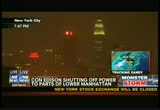
♪ so make them write a big check today. ♪ ♪ and if you're feeling a little slow, ♪ ♪ then 5-hour energy will help you go. ♪ ♪ so buy a bottle of pink lemonade and ♪ ♪ you can help fight breast cancer today. ♪ just gotten word lower manhattan, some areas of staten island, i'm told, i mean the battery in new york city in manhattan and also in parts of staten island, there were concerns that when the water got high enough, then it would begin seeping underneath the city where all the controls are and all the machines are and the steam engines which run the power for the city, that if that salt water got down in there while it was running that it
7:48 pm

would corrode so they were going to turn it off just before there was salt water intrusion. they sent out mobile alerts and text messages today telling everyone who lives in lower manhattan and those areas of staten island they have just shut off power it is a chilly and windy and rainy night. and now darkened in lower manhattan. first alert forecast first alert forecasters -- i also wanted to update you on something else. in new jersey, the ocean has crossed route 36 in near new jersey just south of us come many many blocks inland. but thankfully residents there are still high and dry. there have been a lot of water rescues in the state of new jersey and new jersey governor chris christie seemed lived in a news conference this afternoon admonishing those in atlantic city after the governor said evacuated these areas the mayor of that city said no, you don't have to do that. and now water rescues are being affected and governor christie is angry. first alert forecasters have warned that folks oon long
7:49 pm

island are likely to see this same sort of damage that we have seen and the worst of the storm system giant, a potentially record breaking wall of water. a surge is high at 11 feet. we have a huge wave from rock away beach in queens near long island south shore which they are basically part and parcel of each other. officials say more than 100,000 homes across long island have already lost power and folks may not get their electricity back for more than a week. the chief fox report correspondent jonathan hunt is on long beach, long island where he has been all day. 15 miles east of the rock aways. he has lost power. jonathan, you are back now, what are you seeing? >> shep, we have actually lost power. the entirety of long beach, long island, is now in darkness. we're running off the small amount of battery power we still have. we're using a beacon satellite to get out. all other communications, cell phones, land lines all down right now. over the last hour the situation has become far far worse. and anybody who stayed on this barrier island now has no choice but to wait it out.
7:50 pm
we, for instance, are now trapped in this hotel something like six feet of water on the ground floor. it is rising the management tells us to the mezzanine level. we have been told to stay inside. the board walk behind me is beginning to get water overtopping it even now. out on to the streets right across long island, long beach, long island it, appears that there is major flooding. this is going to be a desperate situation through the night here. nobody has any power. nobody can see anything as they get out there. and can i tell you as i have watched this ocean, shep, you really get the sense that the ocean is moving into and across this barrier island. it is an extraordinary thing to watch. not comparable in any way to anything we have ever seen before. shep. >> shepard: jonathan hunt on scene and what you are hearing in his voice and seeing in the pictures is exactly what the first alert forecasters suggested that as this storm moves its way towards shore, new york, and the city and long island would begin to get pounded.
7:51 pm

high tide is anywhere from between 8:15 and 8:45 eastern daylight time. so within the next 25 to 55 minutes, and as a result, the water is rising all in our area. if you are affected, now is not the time to be outside. breaking news coverage continues right after this. ♪ [ male announcer ] this is karen and jeremiah. they don't know it yet, but they're gonna fall in love, get married, have a couple of kids, children laughing ] move to the country, d live a long, happy life together where they almost never fight about money. [ dog barks ] because right after they get married, they'll find some retirement people who are paid on salary, not commission. they'll get straightforward guidance and be able to focus on other things, like each other,
7:52 pm

which isn't rocket science. it's just common sense. from td ameritrade. can you help me with something? nope! good talk. [ male announcer ] or free windows training when you buy a computer at staples. anotheway staples makes it easier to upgrade.

7:54 pm
en. >> shepard: continuing coverage of the now super storm, no longer a hurricane but also a super storm sandy and the monster storm's high winds and sturgeons have triggered massive flooding across long island. a thin barrier island. beach town roughly six miles off long long island's south sh. the atlantic ocean to the south and great south bay to its north. hundreds much homes sit right there in between. some of them now filled with water as the ocean and the bay continue to rise and may merge
7:55 pm

many year round residents left yesterday under mandatory evacuation orders but some decided to stay behind. one of them is a fire island resident. you can see the entirety of long island. this would be dune road in the hamptons and in between fire island, many areas that you have to go to by ferry. on fire island is karen boss on the phone with us now. karen, weren't you supposed to be out of there? >> they did call for mandatory evacuation but my husband and i stayed. >> shepard: how are you feeling about that decision now? >> i'm still okay. the high tide of the ocean and i'm sitting on the bay. >> shepard: so the ocean and the bay have not met? >> not that i know of at this point. >> shepard: what does it sound like and feel like outside? >> the winds have really picked up. my house is rocking. it's a little nerve wracking. but i think we'll be okay. >> shepard: what town are you in on fire island. >> i'm in fire island pines.
7:56 pm

i'm just going to open the door for a minute. >> not on my account, please. >> it's not so bad on the bay. >> not so bad on the bay. so people can see, fire island is here. this is obviously the ocean side. the sturgeon is hitting from this side and the fear was that at least in some areas along this stretch that it might end up in the south bay. back of it at least until the storm goes north and then you are on the front. >> that's true, although on the ocean we did have a washover in the same spot as when hurricane irene hit. >> shepard: how bad is that? >> it can fill up a couple of feet. >> shepard: be careful out there, i know it's going to be a long night because these winds and the rains are scheduled to continue throughout the night. we have the weather loop again. i want to he show you one characteristic that the weather folks didn't anticipate. here is kind of the center of it right as it goes ashore. all the rain is on this side. the back side is almost completely dry.
7:57 pm

not like a tropical system at all. more like a nor'easter with all of the wetness on this side. can you see it stretches way past cleveland. but up here, not as much rain. tonight, it's wind and sturgeon in new york city as we approach high tide. we're back with with the continuing coverage in three minutes as fox reports live tonight. 'm like...yeah, ok... little did i know that one week later i wasn't smoking. [ male announcer ] along with support, chantix is proven to help people quit smoking. it reduces the urge to smoke. some people had changes in behavior, thinking or mood, hostility, agitation, depressed mood and suicidal thoughts or actions while taking or after stopping chantix. if you notice any of these stop taking chantix and call your doctor right away. tell your doctor about any history of depression or other mental health problems, which could get worse while taking chantix. don't take chantix if you've had a serus allergic or skin reaction to it. if you develop these stop taking chantix and see your doctor right away as some can be life-threatening. if you have a history of heart or blood vessel problems,
7:58 pm

tell your doctor if you have new or worse symptoms. get medical help right away if you have symptoms of a heart attack. use caution when driving or operating machinery. common side effects include nausea, trouble sleeping and unusual dreams. it helps to have people around you... they say, you're much bigger than this. and you are. [ male announcer ] ask your doctor if chantix is right for you. and you are. customer erin swenson bought so, i'm happy. today. sales go up... i'm happy. it went out today... i'm happy. what if she's not home? (together) she won't be happy. use ups! she can get a text alert, reroute... even reschedule her package. it's ups my choice. are you happy? i'm happy. i'm happy. i'm hi'm happy. i'm happy. i'm happy. happy. happy. happy. happy. (together) happy. i love logistics.
7:59 pm

i'm an expert on softball. and tea parties. i'll have more awkward conversations than i'm equipped for because i'm raising two girls on my own. i'll worry about the economy more than a few times before they're grown. but it's for them, so i've found a way. who matters most to you says the most about you. massmutual is owned by our policyholders so they matter most to us. massmutual. we'll help you get there. actually... th way i could split my payments up into little bite-size chunks. i mean you feel me right? yeah. uh, sir... ah... [ male announcer ] shop now. and put it on layaway
169 Views
IN COLLECTIONS
Fox News Television Archive
  Television Archive News Search Service
Uploaded by TV Archive on
